CODOS Update - D6 and D8 Dust Near Top of Snowpacks Statewide
As in past seasons, spring 2013 has seen increasing divergence in statewide snowpack conditions. Not long ago, all Colorado watersheds were experiencing significantly sub-par conditions. However, thanks to recent April storms, Colorado’s northern and Front Range mountains have gained considerable snowpack SWE and begun to approach median SWE values. Meanwhile, the southwestern region has remained comparatively drier.
At the same time, April storms have also delivered three significant dust-on-snow events – D6 (April 8), D7 (April 14), and the very long-duration D8 event (April 15-17) to Senator Beck Basin. Our most recent circuit of CODOS sites earlier in April confirmed the presence of D6 at all CODOS monitoring locations. Recent observer reports indicate that D8 also fell over most if not all of the Colorado mountains, even reaching Boulder, Fort Collins, and Cheyenne.
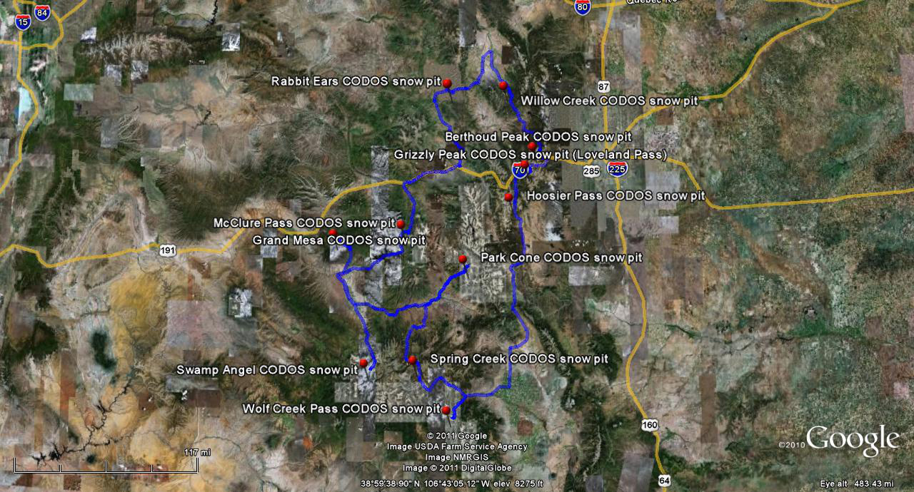
The photos below illustrate the relative positions of D8, D7, and D6 at our Senator Beck Basin Swamp Angel and Senator Beck Study Plots in our most recent snow profiles.

Snow profile #12 of the season on Monday, April 22, 2013 at Swamp Angel Study Plot. Dust layer D6 is the very dark, lower layer, with layers D7 and D8 layers above. The cleaner snow overlying layer D8 (the uppermost layer) contained 1.1” SWE; D6 was underneath 3.2” of SWE. This snowpack, at 11,060’, is fully isothermal and wet throughout.
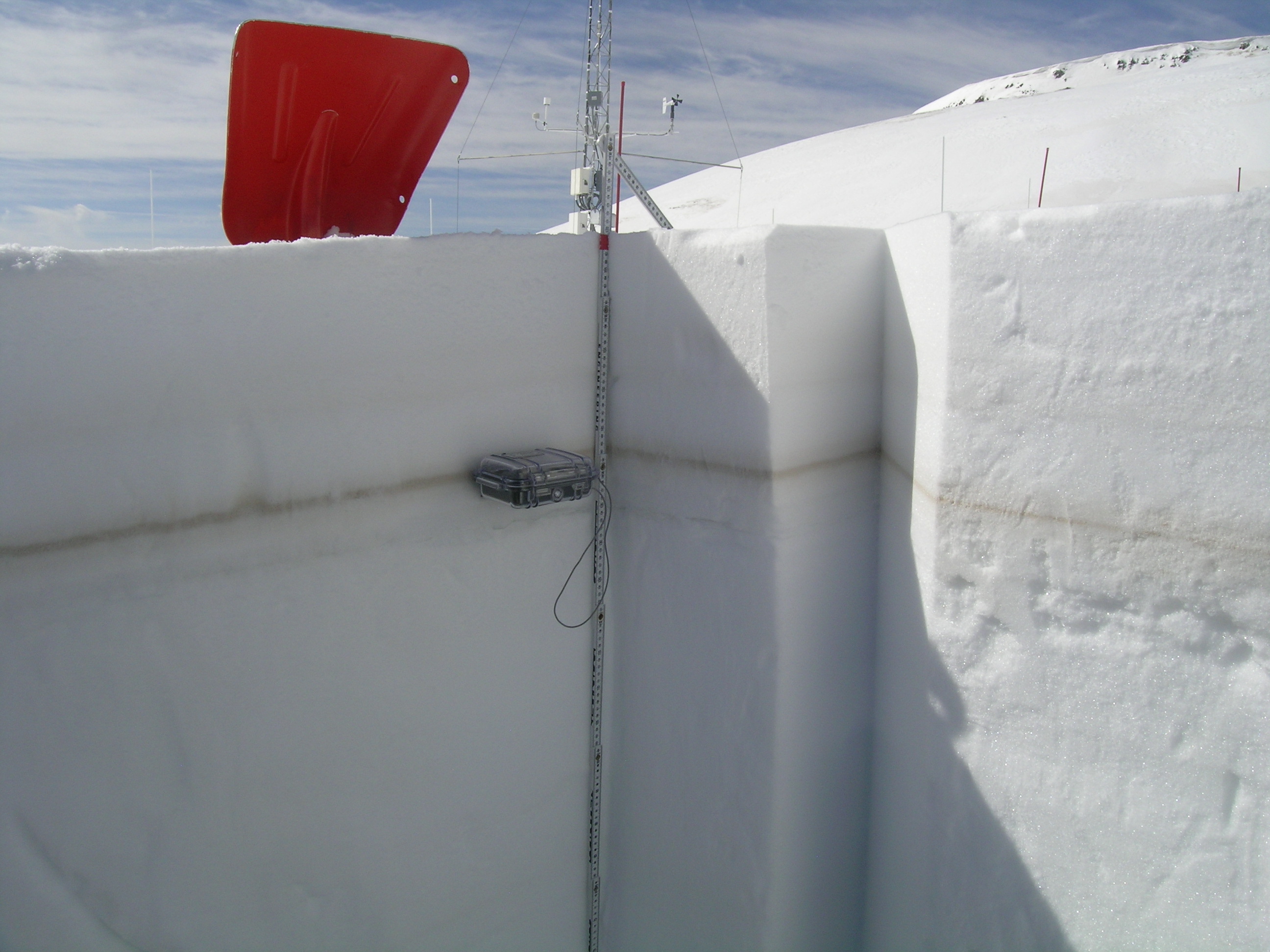
Snow profile #13 on Wednesday, April 24, 2013 at the Senator Beck Study Plot. Dust layer D6 is the prominent layer. D7 is a faint layer some 3” above D6, and D8 is dispersed throughout the upper several inches of snowpack. Wind effects in this alpine terrain produce highly variable coverage of D6, and patches of exposed D6 were at the snowpack surface as we approached the study plot. This alpine snowpack, at 12,180’, still retains cold content, at a mean temperature of -3.6° C, and is still dry throughout.
More recently, the multi-day D8 event actually deposited less dust at Senator Beck Basin than D6, perhaps because it was being carried by exceptionally strong winds and ‘skipped’ our location. The second day of D8, Tuesday, April 16 produced the third highest 24-hour average wind speeds at our Putney Study Plot in our period of record at an average, over the full 24 hours, of 45.2 mph. (Our record 24-hour average was in October 2008, at 49.8 mph). It is plausible, then, that Senator Beck Basin received less D8 deposition than sites farther downwind, where wind speeds had dropped enough to enable dust to ‘precipitate’ to the ground. D8 was a significant event here in the Western San Juan mountains, as seen above, and recent images sent to us and seen during the television coverage of the recent avalanche accident at Loveland Pass suggest that D8 deposition was as intense, and perhaps even heavier, farther to our north and east, all the way to the Front Range. (Dust played no role in the avalanche, to our knowledge.)
Here in the western San Juan Mountains, D8 has begun to rapidly emerge and quickly merge with layers D7 and D6 at lower elevations, severely reducing snow albedo. That emergence and merger process is following the expected elevation and aspect progression and higher slopes still retain substantially higher snow albedo from recent snowfalls, as seen in the photos below near Red Mountain Pass.
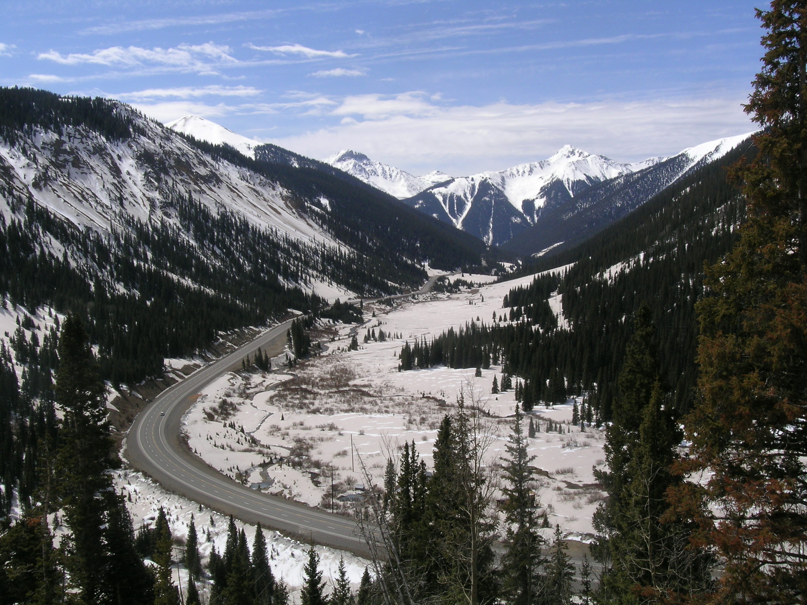
Looking south down Mineral Creek, at Red Mountain Pass, on April 24, 2013. The extremely dirty snow on the valley floor in the foreground is at ~10,300’.
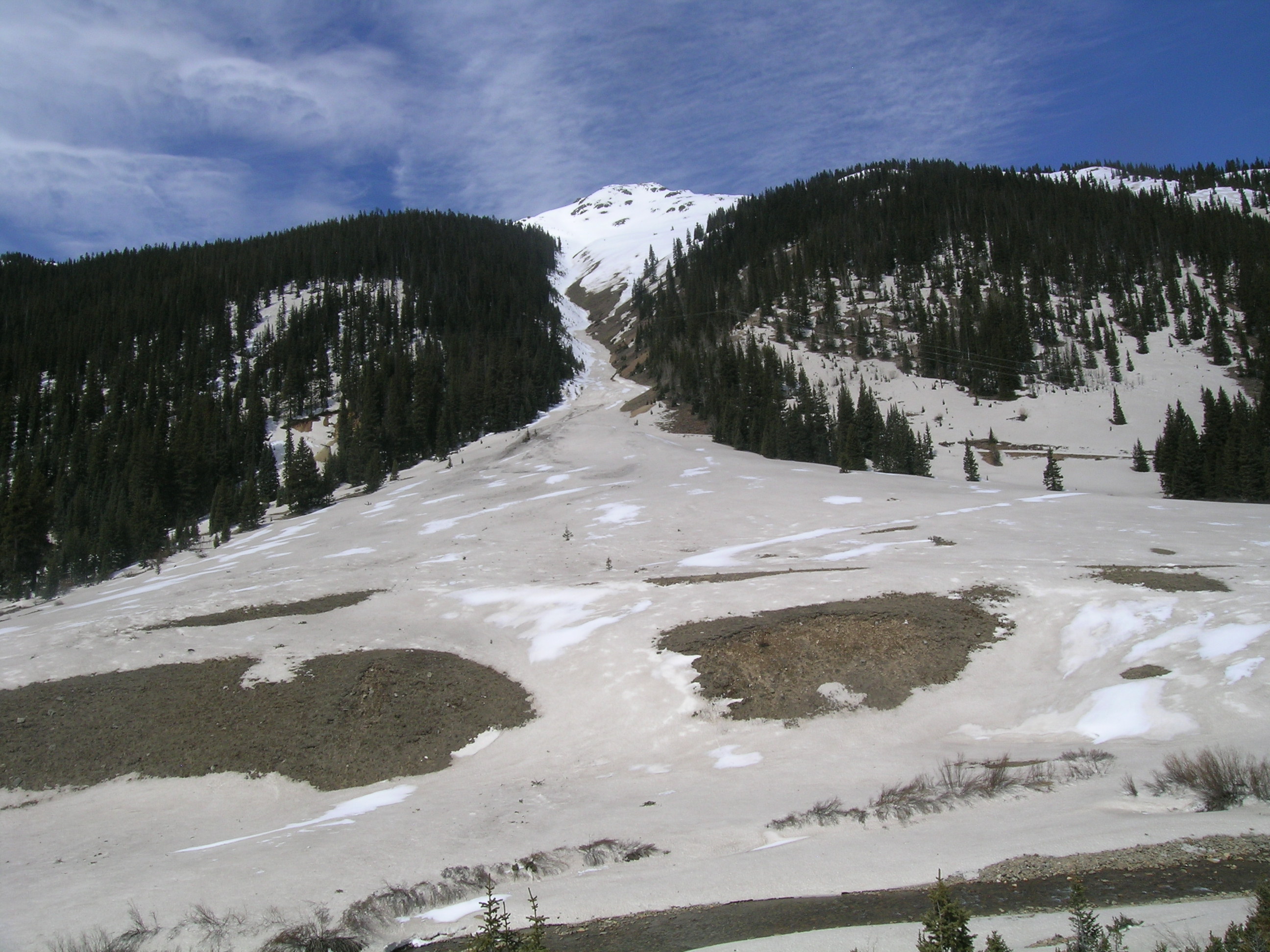
Looking west on April 24 across Mineral Creek, in the valley floor seen in the photo above, at the Riley Boy avalanche path. Dust layers D8/7/6 are all merged and exposed in the foreground. The white summit at the top of the path is ~12,600’.
Our earlier report that D6 was among the heaviest depositions we’d ever observed at Senator Beck Basin actually substantially underestimated the mass loading. In fact, event D6 delivered a little over 47 grams of dust per square meter, based on our sample at the Swamp Angel Study Plot, vastly exceeding any prior single events, even in 2009 (see photo below). In fact, D6 alone delivered more dust mass to Senator Beck Basin, in just 16 hours, than all dust events combined in 2012. Although that intensity was not observed at other CODOS sites, D6 was a substantial event at most CODOS locations.
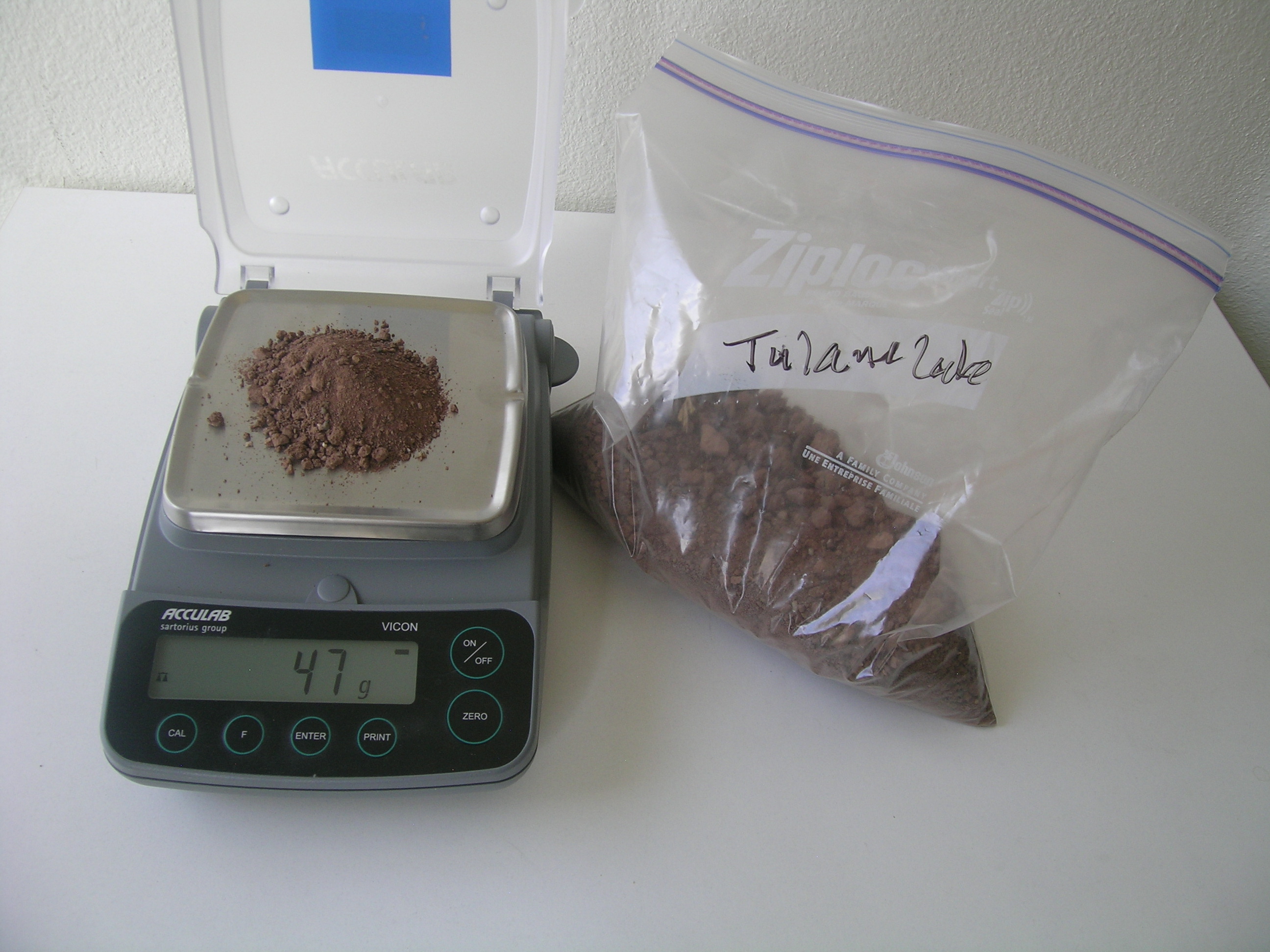
Based on the USGS lab result of 23.7302 grams contained in the 0.5 m2 sample of event D6 (April 8) that we collected at Swamp Angel Study Plot on April 9, an amount of soil from the Tulane Lake dry lake bed near Leupp, AZ was placed on our CSAS digital scale to represent the D6 load on a single square meter of snowpack at Swamp Angel Study Plot, or ~47 grams.
These three April dust events – D6, D7, and D8 – are generally buried by recent snow, but still near the top of the higher elevation snowcover throughout Colorado. At the lower snow covered elevations these layers are already emerging here in the southwestern mountains, and may be on the verge of emerging farther north and east. Table 1 below presents current SWE conditions at the Snotel stations adjoining our CODOS monitoring sites. Based on data from those Snotels, and assuming that no recently accumulated snow has melted, the table also shows our estimate of the amount of SWE overlying dust layers D6 and D8 at the CODOS sites nearby those Snotels. (If present at all, layer D7 would likely lie just below D8.)
 Table 1: SWE conditions as of April 24 at Snotel sites adjoining CODOS monitoring sites, and estimated SWE now overlying dust-on-snow layers D6 (April 8) and D8 (April 15-17) at those Snotel sites.
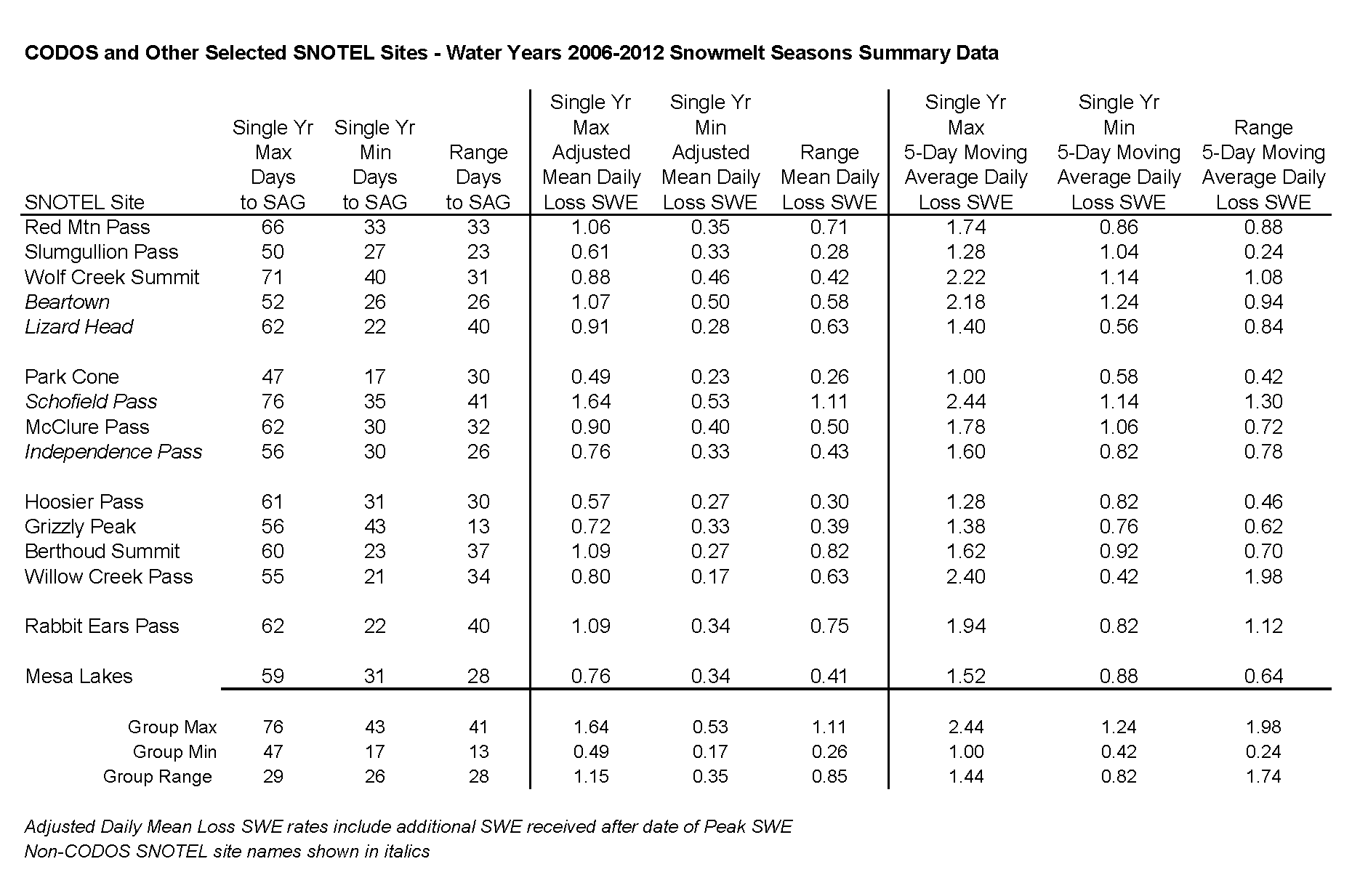
Table 2, above, presents summary data regarding snowmelt rates at those and additional Snotel sites for Water Years 2006-2012. Days to “snow all gone” (SAG), mean daily rates of SWE loss, and 5-day moving average SWE loss rates are analyzed. As of our most recent circuit of CODOS sites, on April 10-12, Hoosier Pass and Spring Creek Pass were the only sites retaining significant cold content; the balance of sites were either on the verge of or fully isothermal. Although recent weather may have interrupted active snowmelt at those previously isothermal sites, and the new snow received since then may contain some cold content, a return to sunny weather may quickly warm those new snow layers and enable a resumption of active snowmelt. Table 2 is intended to provide a reminder of melt rates observed during prior seasons, and describe a range of rates that could erode the snowcover now overlying layers D6 and D8 (as shown in Table 1).
Here at Senator Beck Basin, our stream gauge data have shown no increase in flows in recent days, as would be expected given the still generally high albedo in the basin. Interestingly, stream gauges on the southern and southwestern flanks of the San Juan Mountains - on the Animas at Durango, on the San Juan at Pagosa Springs, and on the Dolores at Dolores - are all reporting significant surging as of this writing. Emergence of merged D8/7/6 is well underway on easterly, southerly, and westerly aspects, up to treeline, as of this writing.
Data for streams draining northward - the San Miguel River near Placerville, the Uncompahgre River near Ridgway, and the Lake Fork at Gateway – have yet to report significant surging. Dust layer D8 has yet to widely emerge on north aspects, let alone merge with layers D7 and D6 (see photo below), but that process is underway.
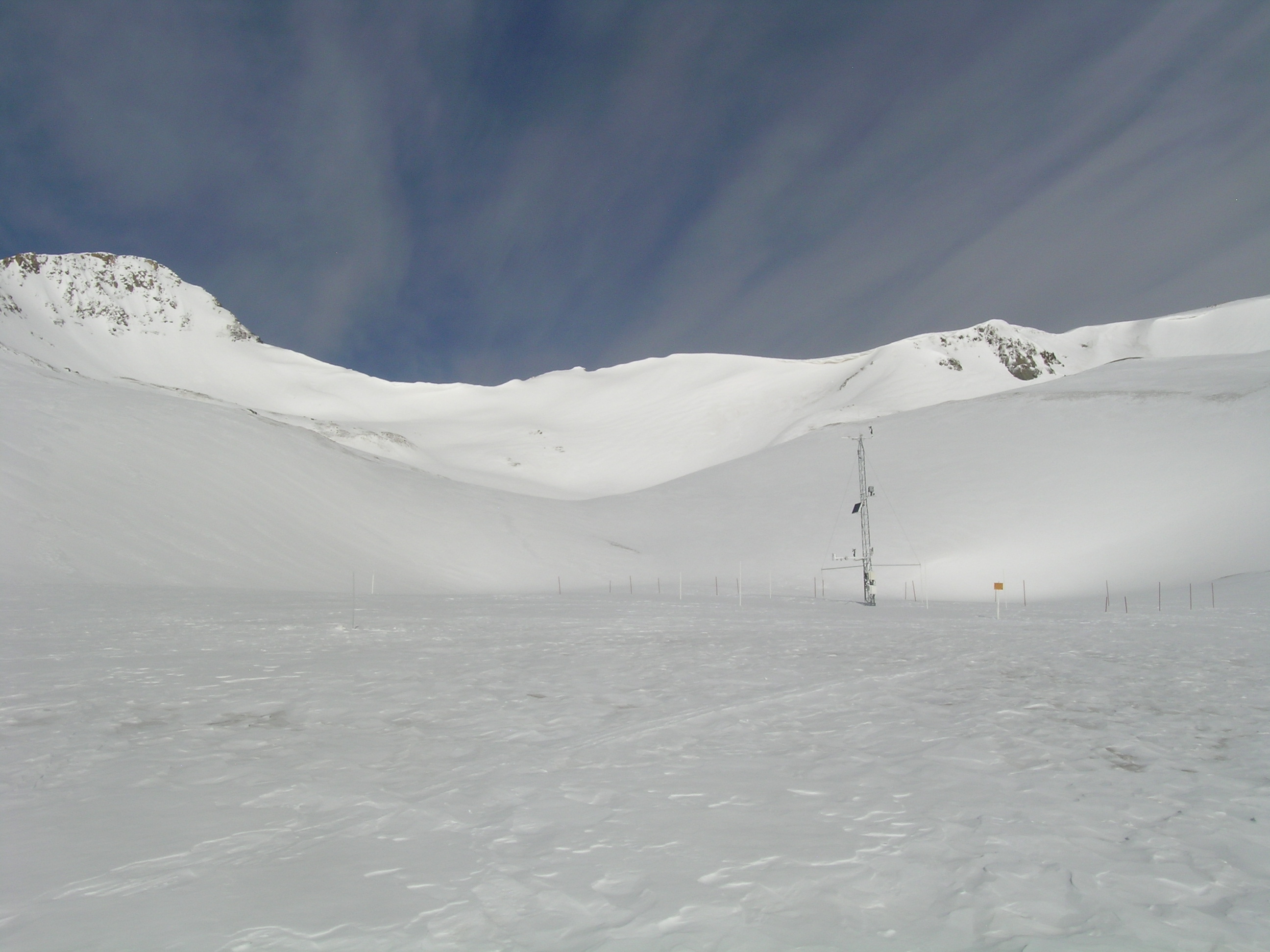
Senator Beck Study Plot (12,180’) on April 24, 2013. Senator Beck Basin retains a comparatively high snow albedo above treeline, with dust layers D8, D7, and D6 still generally buried under recent snowfall. However, wind stripping has scoured small patches down to those dust layers and, like bare ground, those patches of exposed dust are often an origin point for expanding emergence.
Finally, at long last, the Rio Grande at Del Norte is reporting some small increase in discharge, still well below average flows however. As D8/7/6 layers do emerge and merge on all aspects and at all elevations, all streams emanating from the San Juan Mountains will experience significant surging in flows.
As of this writing, the National Weather Service anticipates a return of the sun to the Colorado mountains on Friday, over the weekend, and into the following week. Even “partly sunny” days will be sufficient to drive the emergence of dust layers D8/7/6. A weak disturbance midweek may be followed by a return to dry weather. The CODOS team will attempt to time our next site visitations to maximize the observation of this emergence process, starting in the first days of May.
Chris Landry, Executive Director
clandry@snowstudies.org
Center for Snow and Avalanche Studies
PO Box 190, Silverton, CO 81433 USA
(970) 387-5080
www.snowstudies.org

